Before the Telescope: How Star Maps Made the Sky Legible
See how Ptolemy’s star catalogue and medieval star charts helped observers identify stars, compare positions and pass records between generations.
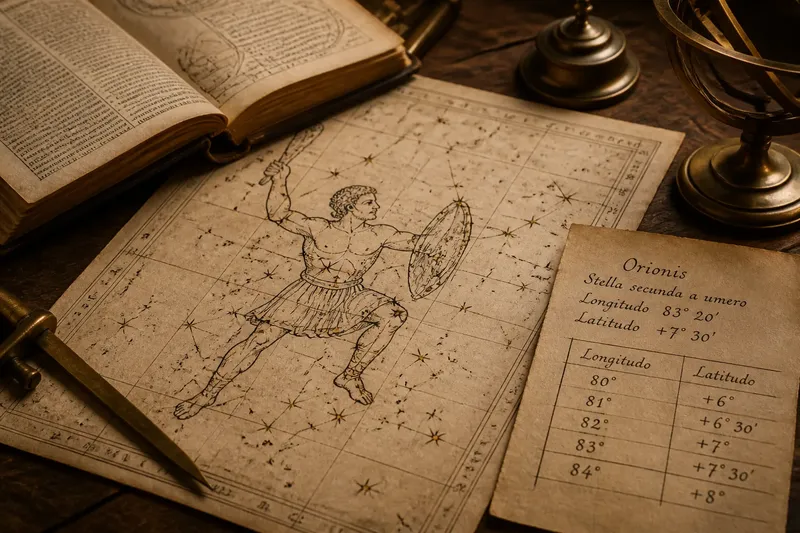
Before the telescope, a star map could turn a familiar group of lights into a set of directions another observer could use. Ptolemy’s ancient catalogue and the star charts made from it show how names, descriptions and recorded positions helped readers identify stars without relying on a drawing alone.
Ptolemy’s catalogue linked stars to a scheme
In the second century, Claudius Ptolemy compiled the Almagest, a work of mathematical astronomy that included a catalogue of stars arranged by constellation. Its entries recorded positions using celestial longitude and latitude, measured against a system based on the celestial sphere. The figures supplied familiar groupings; the numerical descriptions offered a more exact way to distinguish one point from another.
The catalogue was not a modern atlas, and it did not present a single, universally accepted picture of the sky. It was a structured record within a particular astronomical tradition. Later scholars could consult, copy and adapt it, but they also had to interpret its names, conventions and measurements.
This distinction matters: a chart might show where a star appeared in relation to a constellation, while a catalogue could specify its position according to an agreed scheme. The two forms worked rather like a labelled map and an address book. One gives the eye a route; the other helps identify the intended destination.
Star maps before the telescope used figures as landmarks
Constellation figures made groups of stars easier to remember and describe. In the classical tradition represented by Ptolemy’s catalogue, stars were associated with named figures such as Orion and the Great Bear. The lines and outlines later drawn between stars were conventions, not physical marks in the heavens.
A figure was useful because it gave a reader a starting point. An observer could locate a recognisable constellation, then look for a star described as being near a particular part of it. The method depended on shared conventions: a name or figure meant little if the reader used a different arrangement.
Different cultures developed different names and groupings for the stars. A chart should therefore be read as a record from a particular tradition, not as a neutral picture that every observer would recognise in the same way. Even within one tradition, copied diagrams could vary in the lines used to connect stars.
Descriptions and coordinates helped readers check a chart
A drawing conveys arrangement quickly, but it can leave a star’s identity uncertain. A written description can add the detail: which constellation contains the star, where it lies within the figure, or how its position relates to another point. Coordinates add a further reference, allowing readers to compare recorded positions without depending entirely on the drawing.
In the coordinate system used by Ptolemy, celestial longitude and latitude located stars on an imagined sphere. Such records made comparison more systematic, but they did not remove the need for judgement. A reader still had to understand the reference system and identify the stars being described.
Later charts also reflect the history of transmission. A copied position could preserve an earlier record, while a drawing might introduce ambiguity or change. Comparing a chart with its accompanying text and catalogue entry gives a reader more to work with than treating the picture as self-explanatory.
A chart records a tradition as well as the sky
Star maps brought observation together with inherited knowledge. A mapmaker could use established constellation names and arrangements while copying or revising older positions. The result was useful, but it was also shaped by the purposes and conventions of the people who made and read it.
Imagine you have a hand-drawn chart that places a star near Orion’s shoulder, along with a note giving its position in a stated coordinate system. First, identify Orion using the chart’s figure; next, compare the note with the listed position; then inspect the corresponding region of the sky. If the drawing and description disagree, you have a specific question to investigate: whether the diagram, the copied entry or the reader’s identification differs. The chart has not settled the matter, but it has made the disagreement clear enough to examine.
What did star maps show before the telescope?
How did observers locate stars without a telescope?
They used visible patterns, constellation names, descriptions of relative position and, in systematic catalogues, coordinates. These methods organised stars that the unaided eye could distinguish; they could not reveal faint objects or details beyond naked-eye vision.
Were constellation figures the same in every culture?
No. Star names and groupings varied between traditions, so a chart’s figures made sense within the conventions shared by its maker and readers. A familiar modern outline should not be assumed to appear in every historical map.
How did coordinates help with old star charts?
Coordinates gave a star a position within a defined system, making it easier to compare records than relying on a sketch alone. Readers still needed to understand that system and decide which star an entry referred to.
What are the limits of a pre-telescope star map?
It could record visible stars and organise their apparent positions, but it could not show objects too faint or close for the naked eye to distinguish. Its diagrams also reflected human choices about names, figures and lines, rather than literal outlines in the sky.
Why star maps made observations shareable
A star map’s value lay in combining landmarks with a way to identify and compare them. Ptolemy’s catalogue is a concrete example: constellation groupings gave readers familiar regions, while recorded positions offered another means of checking an identification.
For anyone asking how star maps worked before the telescope, the answer is that they joined visible patterns to descriptions and agreed reference systems. Read with attention to their historical conventions, these records let later observers revisit an earlier account and decide what matched the sky—and what needed closer examination.